Tree-Level Drone Mapping & Forest Modeling
Introduction
Our tree-level drone mapping service provides unprecedented visibility into forest structure. Using tree mapping drones and forest survey UAVs, we capture every tree individually, delivering high-resolution data that empowers forest owners, managers, and investors to make informed decisions.
Key Visual to Add:
- Image 1: 3D model of the forest from LiDAR (showing trees, structure, and layout).
- Caption: “3D LiDAR model showing detailed forest structure.”
Why Tree-Level Mapping Matters
Traditional forest inventories rely on sample plots and extrapolations. These methods often introduce error and uncertainty. With drone-based tree mapping:
- Every tree is measured with LiDAR and photogrammetry.
- Species identification is more accurate.
- Tree health can be monitored remotely.
- Investors gain confidence in valuations.
Visual to Add:
- Image 2: Before-and-after comparison (Traditional vs. Drone Mapping)
- Caption: “Comparison of traditional forest mapping vs. drone LiDAR data.”
Methodology
We deploy drones with LiDAR and high-resolution cameras. Data is processed using AI and GIS to produce:
- Individual tree positions.
- Tree height, DBH (diameter at breast height), crown diameter.
- Stem profile mapping for sawlog evaluation.
- Health assessment via crown and spectral signatures.
Visual to Add:
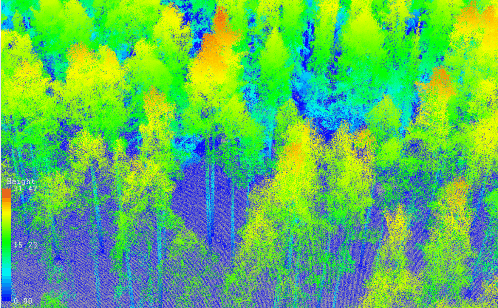
- Image 3: Point Cloud visualization (showing tree positions and detailed data).
- Caption: “Point Cloud visualization representing individual tree positions and height.”
Precision Forest Modeling
Drone data feeds into advanced models:
- Growth and yield simulations with millimeter accuracy.
- Carbon sequestration forecasts.
- Biodiversity and habitat structure metrics.
These models replace assumptions with precise projections.
Visual to Add:
- Image 4: Thematic map showing tree height and other growth parameters.
- Caption: “Height map showing growth projections using LiDAR data.”
Digital Twin Creation
A forest digital twin is a 3D virtual replica of your forest. It allows:
- Simulation of thinning, harvesting, and regeneration.
- Testing management strategies without risk.
- Climate impact modeling.
- Visualization for remote stakeholders and investors.
Visual to Add:
- Image 5: Digital twin of a forest, showing interactive management strategies.
- Caption: “Interactive 3D digital twin used for forest management simulations.”
Benefits
- Decision confidence with detailed data.
- Improved ROI by reducing uncertainty.
- Sustainability through biodiversity monitoring.
- Faster, cheaper, and more scalable than ground surveys.
Visual to Add:
- Image 6: 3D LiDAR forest model with detailed height and tree structure.
- Caption: “3D LiDAR model showing detailed forest structure, providing clear decision-making insights.”
Use Cases
- Private owners validating timber volumes.
- Investors conducting acquisition due diligence.
- Managers optimizing thinning.
- Carbon projects establishing baselines.
Visual to Add:
- Image 7: Segmentation of tree heights for forest management use.
- Caption: “Height segmentation of trees used in forest management for precise thinning and growth projections.”
Final Call to Action (CTA)
Ready to unlock the full potential of your forest?
Contact us today to explore how our precision forestry solutions can help you maximize returns, secure sustainability, and protect your assets.
Button:
Request a Consultation → (link to /contact)
Visual to Add:
- Image 8: Map of study area with marked boundaries (to represent the overall forest area covered by the service).
- Caption: “Study area map showing the scope of the forest assessment and data coverage.”